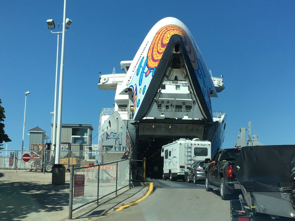
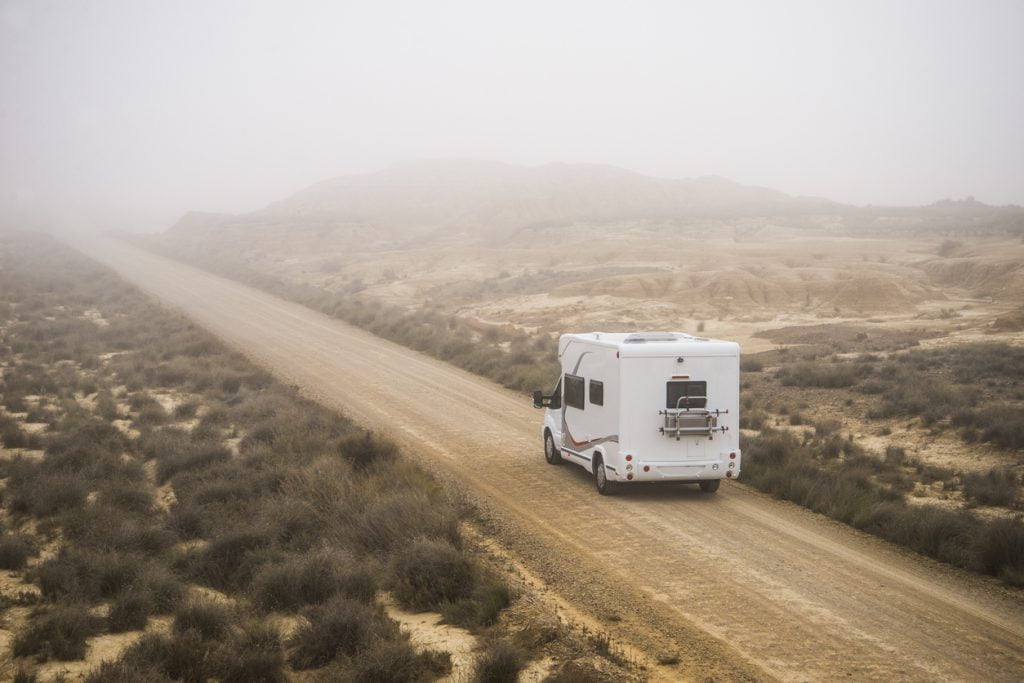
I grew up with a family cottage on the shores of Ontario’s Georgian Bay, not far from Manitoulin Island. But it was many years later, adult travel in a Class B camper van, before I made the scenic ferry crossing on the MS Chi-Cheemaun from the mainland to Manitoulin, to explore the largest freshwater island in the world.
Once there, and after several days of travelling the island’s backroads, I did not want to leave. I found myself scanning the realty listings and imagining it in the four seasons. In winter, the RV would, of course, be stored away. But springtime brings tapping of the maple trees; in summertime every day would be filled with swims, hikes, and hopping from one farmstand to the next; fall is a splash of colour as the hardwoods turn orange, red, and gold.
Manitoulin is known for its Indigenous communities, where more than one-third of the island residents are part of eight First Nations territories. The name Manitoulin means “island of the great spirit” and the island has a deep spiritual significance to many of its residents. In the summer months, sacred pow-wow events are a showcase of traditional ceremonial songs and dances. Archaeological and oral evidence supports more than 10,000 years of Indigenous occupation on Manitoulin Island. A date to highlight would be on or around June 21st, National Indigenous Day, when pow wows, competitive dance and song, and other cultural events are in full swing.
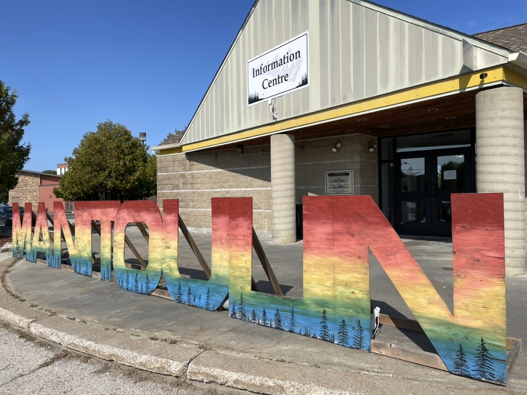
We visited in the autumn and wanted to take short road trips, stopping in at the must-see spots of Manitoulin. The welcome centre at Little Current was an excellent starting point, where the staff unfolded a paper map and drew the exact routes to take, including sideroads and shortcuts we would have otherwise missed. Here’s a look at the route we followed and the gems we discovered. For longer trips, there are so many more to be explored.
Stop #1: Ten Mile Point
Highway 6 is the north-south roadway connecting the ferry dock at the south to the famous Iron Bridge at Little Current at the north end of Manitoulin. Look for the turnoff to Ten Mile Point and the Ten Mile Trading Post and Gallery. The small shop is operated by the First Nations and is filled with beautiful handmade crafts like dreamcatchers, moccasins, soapstone sculptures, drums, paintings, and literature. Out front there is an observation deck with breathtaking views over the shimmering blues of Sheguiandah Bay and Manitowaning Bay.
Ten Mile Point comes with beautiful lookouts, but there are many other galleries and trading posts to visit across the island.
Stop #2: Centennial Museum
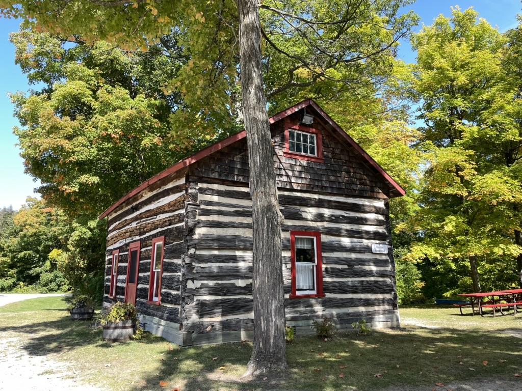
Just off Highway 6, and not far to the north from the Trading Post, is the Centennial Museum of Sheguiandah (modest entry fee). For millennia, people have been drawn to Sheguiandah for the silica outcrops that were used for tool making. The museum tells the story of the pioneers who settled in the area after the Manitoulin Treaty of 1862. The new interactive interpretive centre showcases 9,500 years of human activity in the community. There are artifacts at the museum as well as several historic buildings that can be toured.
Stop #3: Cup and Saucer Michigiwadinong Hiking Trail
Continue north along Highway 6 and then head west along Townline Road, then Litmus Kiln Road, left on Bidwell Road, and then left again on Highway 540. It’s a shortcut off the main highway that crosses through beautiful rolling woodlands, wetlands, and tidy farms. Heavily forested with maples, this would be a striking drive in springtime when the trees are being tapped, and in autumn when the colours are changing.
Not far after turning onto 540 from Bidwell Road, watch for the signs that say Cup and Saucer Hiking Trail, a name referring to its unique geological characteristics. The upper parking lot (closer to the trailhead) is better suited to larger RVs and there is plenty of room for parking and turning around.
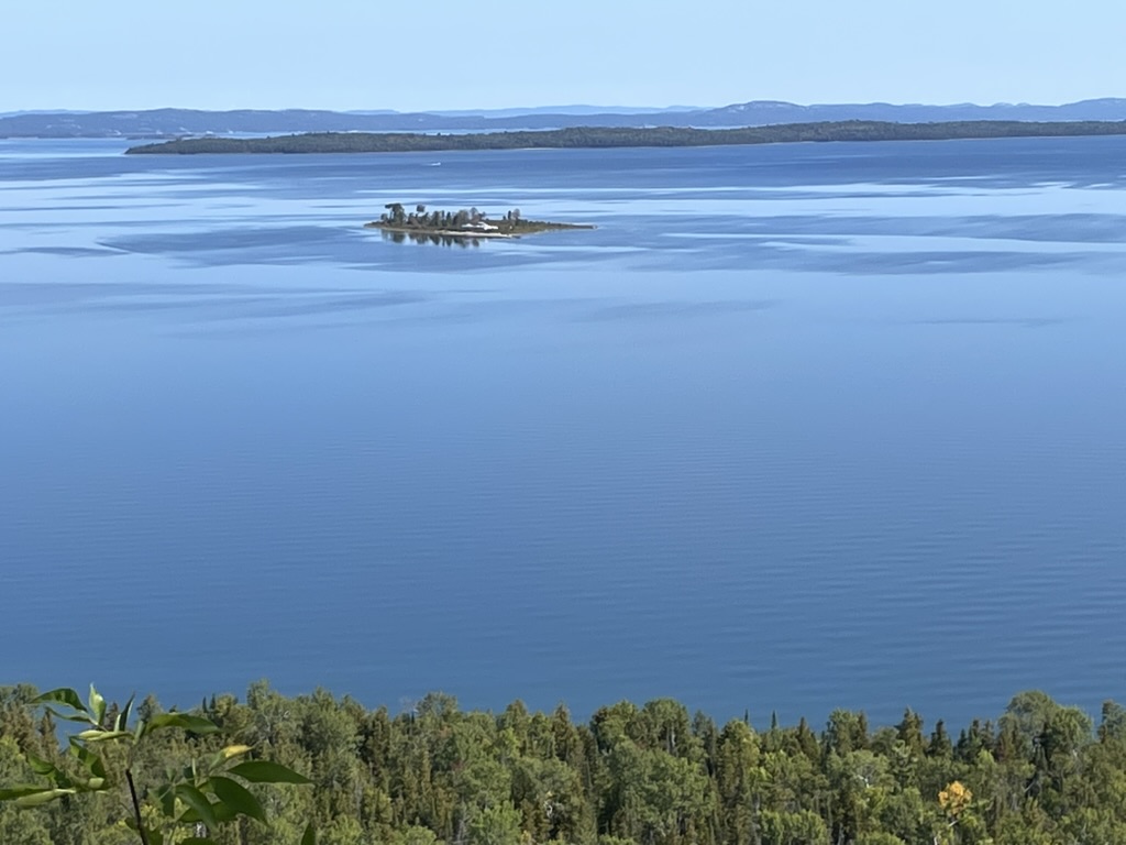
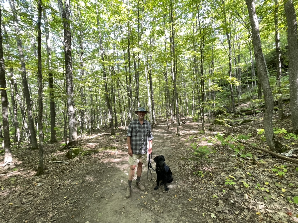
The Cup and Saucer Trail (no entry fee) is a hiking magnet for outdoorsy types on the island, boasting some of the best views. Its name comes from an Indigenous story of an Anishinaabe trickster. The route climbs ridges that form the final stretch of the Niagara Escarpment, an Ontario landform created millions of years ago when sediments were laid down in a tropical sea that was (at that time) south of the equator. Over time, the softer soils have been eroded away to reveal dramatic 70-metre cliffs. In the summer months, the views are of the North Channel on one side and Lake Manitou on the other.
There are two hiking options: a 90-minute return “half loop” or a three-hour return to the dramatic lookout. Both well-maintained trails pass through a magnificent mature forest of maples and past towering rock outcrops. Note that there are some steep sections and a vertical ladder that may pose challenges for some. Dogs are welcome but must be on leash.
Stop #4: Bridal Veil Falls
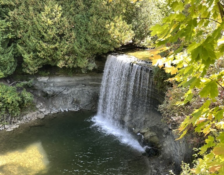
After hiking the Cup and Saucer, point your RV southwest along Highway 540 and follow the roadway along to the well-signed Bridal Veil Falls (no entry fee), just before the village of Kagawong. The falls are the number one visitor attraction on Manitoulin Island and the parking lot at the entry is not suitable for larger RVs or for travel trailers. Even fitting our Class B van was a challenge. There are several nearby parking alternatives in lower Kagawong.
The Bridal Veil Falls was known to Indigenous peoples as “Kagawong,” meaning “always foggy.” The pretty waterfall and river have cut through the landscape and sit at the bottom of a small gorge. There is a steep metal staircase with lookout points from the very top to the waterside at the bottom. We found it an easy climb but someone with mobility issues may find it safer and more comfortable to take in the view from the top. Visitors can go for a dip at the pool in front of the falls, snap photos behind the cascade of water, or just sit quietly on the shore and contemplate the magic of the setting. For those who want to take some time for a hike, there’s also a riverside trail along both sides of the Kagawong River from the falls to the bay waters of Lake Huron’s North Channel.
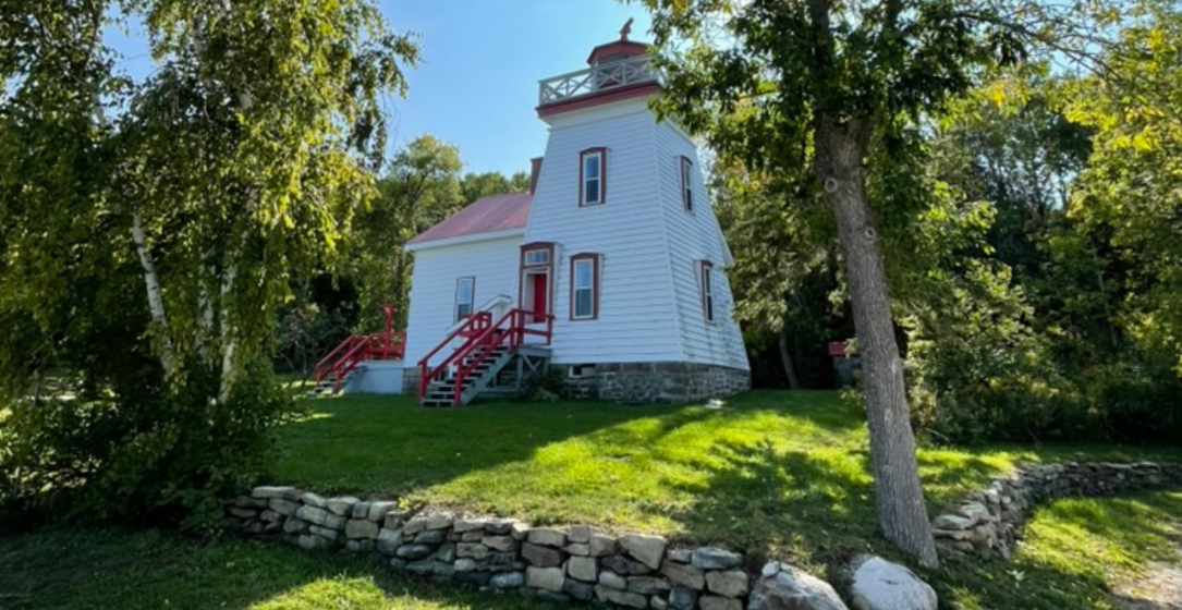
Stop #5: Janet Head Lighthouse
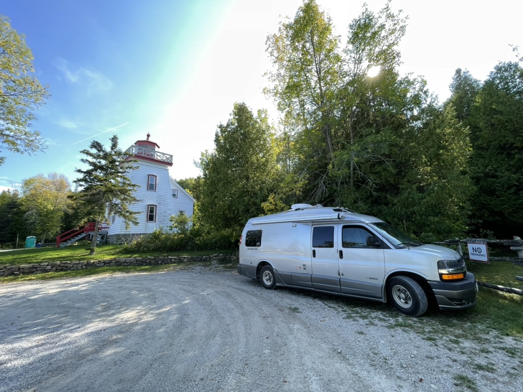
We continued along Highway 540, turning north at 540B toward the waterfront town of Gore Bay, with its large marina and views over the lake’s North Channel. For many years, the packet steamer that travelled between Gore Bay and the North Shore was a lifeline for Manitoulin residents, taking them to the CPR train lines that connected them to the off-island world. Our goal was Lighthouse Road, a short drive from town that dead ended at the historic and picturesque, red and white Janet Head Lighthouse.
Built in the late 1800s, Janet Head is an example of the classic Georgian Bay lighthouse style, where the lightkeeper’s home is a part of the structure. Its light could be seen 18 kilometres out over the water. In the summer it guided shipping vessels; from 1910 to 1924, when the channel was frozen over in winter, the flashing light directed sleighs carrying the mail between Gore Bay and Spanish on the North Shore.
Since the late 1960s, the lighthouse has been under private ownership, although visitors are welcomed to the grounds and the lighthouse is opened several times each week during the summer months for tours.
Renowned as a spot for fossil hunters, the rocks and water at the end of Lighthouse Road took me back to good memories of summer’s spent along the Georgian Bay shoreline. The cold, clear water of Lake Huron. The small rocks we would smash together to find the trilobites and cone fossils hidden inside. The vistas over the expanse of blue water. It may have been my first time diving deep into the magic of Manitoulin Island, but there were strong threads connecting it to my childhood summers many years ago.
_____________________________________________________________________________
PLACES TO STAY
Chutes Provincial Park is on the mainland, just north of Manitoulin Island and an hour drive from Little Current. It’s the only provincial park on the Trans-Canada between Sault Ste. Marie and Sudbury. The park is known for its scenic falls and swimming spots.
There are no provincial parks with camping facilities on the island, so we opted for a Harvest Hosts site at Farmer Ted’s. Complete with delightful hosts, farm fresh eggs, a delicious garlic aioli and roosters crowing as the sun breaks the horizon. At night, the lack of light pollution meant a sky pecked with stars and a clear view of the Milky Way. Manitoulin is well known for its dark skies and opportunities for stargazing. Although we did not stay there, we also heard good reports of the private Batman’s Cottages and Campground.
On the Tobermory side, Bruce Peninsula National Park’s Cyprus Lake Campground has 232 drive-in, un-serviced sites. Just south of Owen Sound at Chatsworth is Gibson’s Honey, a fantastic Harvest Hosts and Terego member site.
www.exploremanitoulin.com
www.destinationontario.com
www.ontarioferries.com
Related Articles
Weather Apps for RVers
Planning for that epic road trip this year? In addition to checking we’ve the right insurance coverage, it’s becoming increasingly more important to also plan for the possibilities of extreme weather and wildfires on our journey. Last year (2023) more people were...

Peace of Mind on the Open Road
How Canadian Snowbirds 65+ Can Navigate Rising Medical Insurance Costs As Canadian snowbirds prepare for the 2025–2026 winter travel season, many are rethinking their plans. The cost of out-of-country and out-of-province medical insurance has risen sharply over the...
Saint John, New Brunswick: A City Reinventing Itself
Saint John, New Brunswick's young entrepreneurs are reinventing the city as a tourist destination, a place to live, and a place to camp. First View of the City Be daring; you can take a detour on approaching the city from the southwest. Use your GPS and cross the...

