It is easy to say that southern Utah is our favourite place to explore and hike, but it is almost impossible to select only one favourite destination in this high desert region of the Colorado Plateau. This is the land of open blue skies and endless landscapes, of red sandstone, slot canyons, arches, buttes, natural bridges, native art and ancient cliff dwellings, and of the Milky Way radiating from horizon to horizon on moonless nights. Travelling through southern Utah’s extraordinary, irregularly-shaped rock formations, brightly stained with colourful minerals, causes us to contemplate our earth’s violent beginnings. What an exhibition geology has created for us!
Southern Utah has five national parks, seven national monuments, a National Recreation Area and numerous historic sites and state parks. The vast majority of southern Utah is public lands administered by the National Park Service (NPS), the Bureau of Land Management (BLM), and the US Forestry Service (USFS), so the opportunities for exploring outstanding natural wonders are overwhelming.
The national parks have become more popular with travellers during the past 30 years. During our first visit in 1987, these parks were busy, but not too crowded. Today, millions of tourists descend on these breathtaking parks every year. Off-season is the best time to visit if you want to escape the biggest crowds, say perhaps from December through February, although you’ll need to be prepared for cooler temperatures, possibly even snow. While we have visited each of the five national parks several times, we prefer more remote, unfamiliar locations for their solitude. Nevertheless, we do love the “Mighty Five” as the national parks are known; each is so different from the other, and all are worthy of a visit.
The Mighty Five
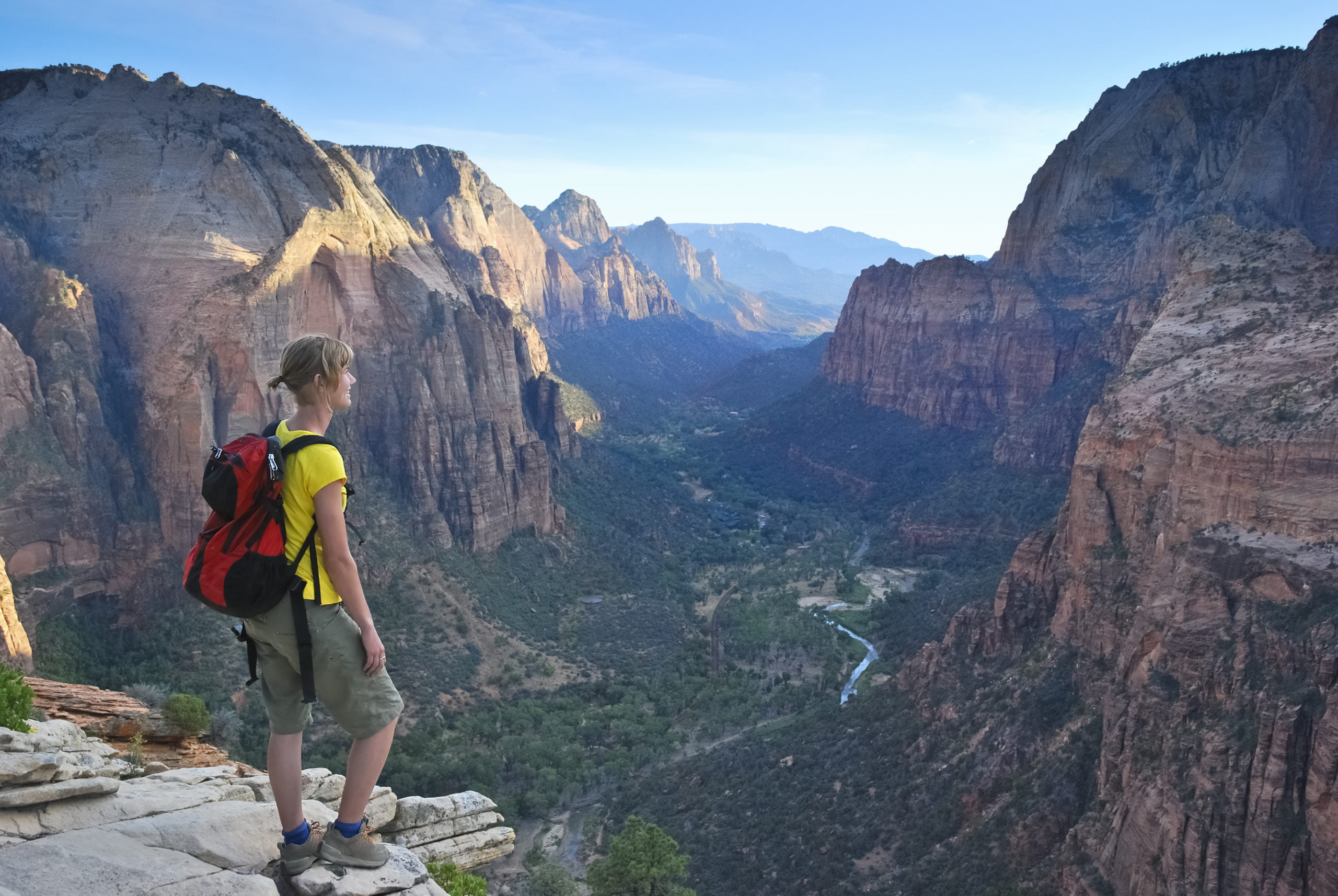
Zion is the western-most national park, near the city of St. George. In 2015, Zion received the most visitors of the “Mighty Five” at over 3.6 million, with the least visited months being December and January. Zion has many areas that are impressive to see without hiking, like Checkerboard Mesa and the Towers of the Virgin, but we like to get out and touch the beauty. Angel’s Landing is our favourite hike in Zion; it’s also one of the most strenuous with over 1,500 feet (457 m) of elevation climb, but exhilarating with 1,000 foot (305 m) sheer cliffs on either side of the trail’s narrow ledges, ostensibly made safer with chains drilled into the rock walls or strung through metal posts. The 360 degree views of Zion Canyon from the peak make the risks seem inconsequential; we were standing on top of the world in utter reverence.
Travelling eastward, Bryce Canyon is the next national park and the second-most visited. The smallest of the five national parks in area, it does not disappoint by comparison. At an elevation of between 8,000 and 9,000 feet (2,400-2,700 m), Bryce Canyon sees winter snow, which can arrive early and stay late. We actually look forward to one day experiencing how the white stuff we drive so far to avoid each year augments the ragged splendour of the multi-coloured pinnacles. Whereas in Zion, you tour through the canyon and gaze skyward at the red cliffs and rock formations, in Bryce, you drive along the rim and peer down into the canyon which has the world’s largest collection of colourful hoodoos. Several outstanding hikes, like Queens Garden, Navajo Trail, Fairyland Loop or Peek-a-boo Loop, take you deep into Bryce Canyon where true perspective helps you understand the size and beauty of these towering spires of orange and pink rock. Cedar Breaks National Monument, 21 miles (34 km) east of Cedar City, may be a quieter alternative with similar hoodoo formations, although we haven’t had the opportunity to visit there yet.
Capitol Reef lies in the middle of the pack in both geography and visitation, and is definitely not a park to be missed. Like Bryce Canyon, many of the rock formations can be seen from the many roadside pullouts, but our preferred areas of the park involve longer trips to the northern and southern tips of this 60 mile (97 km) long park, and are accessed only by dirt roads. In the north, Cathedral Valley is an extraordinary expanse of desert, showcasing volcanic dykes, a gypsum sinkhole, and colossal rock monoliths with names like Temples of the Sun and Moon, not to mention the fabulous drive over Thousand Lakes Mountain Road, especially in the fall, when the aspens dot the mountainside with gold. In the south of the park, the Waterpocket Fold, a “wrinkle on the earth” or a monocline that has eroded to reveal multi-coloured rock layers from deep within the earth, is a favourite destination of ours to which we can’t help but return. We marvel at how the earth thrusts solid rock deep from within to present us with such a dazzling display of colour and texture. Visible from the Notom-Bullfrog Road, from one of several hikes into the fold like Headquarters Canyon, or from either the Strike Valley Overlook or Halls Creek Overlook, the 100 mile (161 km) long Waterpocket Fold is a remarkable yet hidden gem of Capitol Reef National Park.
As the largest national park in Utah, Canyonlands encompasses four different areas, the two most popular being the Island in the Sky and the Needles Districts. We are eager, in future trips, to visit the more remote Maze District and Horseshoe Canyon Unit, the latter of which contains a vast collection of native rock art. Like the distinction between Zion and Bryce Canyon, in the Island in the Sky District, you are looking down into the canyons irregularly cut by the Green and Colorado Rivers, creating islands of mesas. We drove the 4×4 Shafer Trail, a series of switchbacks, which descends to the flat mesa above the Colorado River, where we spent a glorious day chatting with groups of cyclists who rode for several days along the White Rim Road, and touring the mesa rim past views of Dead Horse Point State Park as far as the impressive expanse of Musselman Arch. In the Needles District, you are in the canyon looking up at the rock spires. Chesler Park, in the Needles District, is a pleasant 6 mile hike (9.7 km), traversing through serene open scrub desert, towering red-rock pinnacles, a section of narrows, and rugged, dry creek beds. If you love rock scrambling as we do, the Squaw Canyon/Big Spring Canyon hike is an invigorating 7.5 mile loop (12 km) that crosses over a steep, slick rock (sandstone) ridge between the two canyons. Both districts also have shorter, easier hikes where you can see splendid arches, domes, weeping walls, potholes, and native ruins.
Located just north of Moab, Arches National Park boasts the world’s largest collection of arches with over 2,000 natural, red-rock arch formations. The Double O Arch hike (4.2 mi/6.8 km) requires some climbing and walking on narrow fins and ledges as it follows the initial few miles of the Devil’s Garden Loop Trail. It’s this type of challenging hike that thrills us, giving us a sense of accomplishing something a little daring at the end of the day. Views of the La Sal Mountains, snow-capped during periods of the year, make a stunning backdrop to the many arches along this trail. The most popular park hike is the ascent to Delicate Arch (round trip distance 3 mi/5.5 km), or you can make the shorter climb to the Upper Delicate Arch Viewpoint which also provides striking views into the deep canyon between the viewpoint and the famous arch. Incredible Delicate Arch has become the iconic symbol of this park, and perhaps Utah itself.
Our Secret Favourites
While we love and thoroughly enjoy every visit to the “Mighty Five”, the Grand Staircase-Escalante National Monument (GSENM) is our preferred destination, covering almost 1.9 million acres of public lands. The area is so vast that we typically spend a week or more near the towns from where the GSENM can be most easily accessed: Escalante, Boulder, Kanab, and Cannonville. This is slot canyon country, carved by the plethora of tributaries of the two main rivers which dissect the GSENM – the Escalante and the Paria – and the hikes here are unparalleled. As an added bonus, since it’s a national monument administered by the BLM, free camping is allowed (and we love that!), and there are several tranquil, alluring locations where we can fit our 31-foot fifth wheel trailer, although there are few paved roads into this vast, remote interior, so checking road conditions ahead of time is essential.
The highest concentration of slot canyons is found along Hole in the Rock Road, just outside of Escalante. A slot canyon is very narrow, typically 5 to 20 feet wide (1.5m to 6m) with high walls, often overwhelming our senses by their smoothly rounded shapes and sheer size. With names like Peek-a-boo, Spooky, Zebra, and Tunnel, each canyon trek brings its own challenges. Peek-a-boo slot is a favourite of ours, and was totally different the two times we’ve hiked it. The first time, the only challenging obstacle was the initial 12-foot climb straight up the wall using finger and toe holds scraped into the sandstone. The second time, not only did we have to scale the wall to access the slot, but most of the sand had been washed out of the slot’s potholes during summer monsoons, making passage through the canyon much more challenging than our previous easy walkthrough. Want something a bit less strenuous? Drive 10 miles down the well-graded Hole in the Rock Road to the Devil’s Garden, where you can picnic among the strange red hoodoos. Stop at the Interagency Visitor Centre in Escalante, where the friendly staff can give you helpful information, and you can purchase detailed topographical maps if you plan to explore some of the lesser travelled back roads or trails.
In this same area along Hole in the Rock Road, Golden Cathedral was always a bucket list spot of ours. Located near the lower end of Neon Canyon, two huge potholes hang suspended in the ceiling of an alcove about 80 feet (25 m) above a cold pool. These potholes open into the floor of the upper section of Neon Canyon. A popular spot for rappellers, it is a stunning sight to behold. The colours of the red rock, intensified by the light reflecting inside the canyon, and the walls rounded and smoothed by the swirling currents that occurred during previous flash floods, give us the impression we are indeed in a spiritual place. We did the hike in the fall of 2015 from the Egypt trailhead as a loop, travelling cross-country through sand to the Escalante River, fording the river, and hiking up Neon Canyon (the short distance to Golden Cathedral), where we were lucky enough to catch three rappellers dropping through the pothole in succession. After eating lunch and taking hundreds of photos, we returned to the Escalante and hiked up-river, including five knee-deep river crossings, to find the entrance to (or exit of?) Fence Canyon, then made our way up that canyon back to the parking lot, a total of about 9.5 miles (15 km). We left the trailer at sunrise, and returned after sunset, exhausted but euphoric! Golden Cathedral – check!
Hole in the Rock Road also has historic significance as the route of Mormon settlers who, from 1879 to 1880, forged a trail from Cedar City, Utah, to the site today known as the town of Bluff, Utah. The road is named for the narrow crack in the rock through which they drove their wagons, teams of horses, cattle and families to reach the Colorado River, nearly 2,000 feet (610 m) below. A captivating film at the museum in Escalante depicts how difficult and terrifying the journey was. This is an amazing and heroic story of pioneers who braved all, to which I couldn’t possibly do justice, but it is well described on the National Park website at https://www.nps.gov/glca/learn/historyculture/holeintherock.htm and the Mormon Historic Sites website at http://mormonhistoricsites.org/hole-in-the-rock-expedition/.
There is so much to see. From here, we access the GSENM along Cottonwood Canyon Road (aka Cottonwood Road), the site of another monocline called the Cockscomb.
From Kanab and Highway 89, we access the GSENM along Cottonwood Canyon Road (aka Cottonwood Road), the site of another monocline called the Cockscomb. This area is rife with red and white hoodoos called toadstools for their large caps and colourful rock formations in red, orange, yellow, and pink, including the aptly named Candyland region. Our favourite hike is up Yellow Rock, a large dome with bright patterns and deeply textured ridges that charm the camera lens with flowing rivers of colour.
In the same area, south of Highway 89 between Kanab and Page, Arizona, is House Rock Valley Road, the access point to the famous rock formation known as The Wave, in the Vermillion Cliffs National Monument in northern Arizona. Only 20 people are allowed to hike to The Wave daily, and they are chosen by a lottery system. We won that lottery in 2012, after three attempts meeting at the Bureau of Land Management (BLM) office in Kanab at the specified time. We were ecstatic to be awarded this honour because The Wave is a very extraordinary place. After hiking for a couple of hours, you climb a sandy hill and enter through a long corridor that teases of what’s to come, finally emerging into a bowl of undulating red and white striped rock. The effect is almost dizzying. The surrounding areas of Coyote Buttes North and South are as scenic as they come, including White Pocket, the Teepees, and Cottonwood Cove, but check first with the BLM office in Kanab as some areas require a permit and/or lottery selection, and roads can be hazardous.
Second only to the GSENM is the Glen Canyon National Recreation Area, an enchanting, rugged place worthy of extensive exploration. Most commonly accessed by boaters from Page, Arizona, at the Wahweap Marina or Antelope Point Marina, most of the Recreation Area is inside Utah. This is Lake Powell, a reservoir created by the Glen Canyon Dam that was built in the late 1950s, and provides an abundance of recreational activities and amazing scenery of cool, aqua water set against the hot, parched red desert. About 40 miles up the lake is Rainbow Bridge National Monument, one of the world’s largest natural bridges, and a popular tour boat destination, although we still have this spot on our bucket list.
In December 2015, we found Alstrom Point, where we discovered a secret view of Utah’s heart. From Alstrom Point, you can see Navajo Mountain, several of the 96 major side canyons, and many of the near 2,000 miles (3,160 km) of Lake Powell shoreline, which is more than the entire west coast of the United States. At sunset, the red rock reflects its fiery, orange glow into the deep, blue lake. The rim at Alstrom Point is many miles long, and we spent hours running around like squirrels trying to see the view from as many different angles as possible, until the desired photo had been shot.
Although not in southern Utah but very near its border, there are many other spectacular sites near Glen Canyon and Page, Arizona. Horseshoe Bend is a famous spot, photographed annually by millions of visitors. From the east rim near Highway 89, the view west is of the Colorado River some 1,000 feet (305 m) below, and the rim opposite is in the perfect shape of a horseshoe. Its popularity is increased because of the visitors who come to Page to see Antelope Canyon, a world-class destination, and the most photographed slot canyon in the world. On Navajo land, access to Antelope Canyon is by guided tour only, and prices are fairly steep ($40/person plus $8 permit fee). You will never be alone in the slot, but it is so spectacular it is worth experiencing at least once in a lifetime. This canyon is overwhelming if you visit at the right time of year, when the sun is high enough to focus beams of light through the swirling ceiling onto the sandy floor. It is truly an ethereal experience. Another fantastic destination is the 75 mile (120 km) long San Rafael Swell, east of Green River. The Swell is an anticline (a dome-shaped bump on the earth) with abundant slot canyons, scenic rock formations, and nearby whimsical Goblin Valley State Park. Little Wild Horse Canyon is the most popular and prettiest slot canyon in the Swell. Easily accessed from Goblin Valley Road, this canyon is a fun 2-3 hour hike with beautifully textured and coloured walls, leaving us to wonder how nature’s erosive
forces can sculpt such berserk shapes and patterns. Crack Canyon is another favourite, accessed from
Behind the Reef Road, a dirt road which may be passable only in a 4-wheel drive, high clearance vehicle. Both hikes are moderate with a bit of rock scrambling required. The Goblin Valley State Park staff is very helpful with information about the local canyons and roads. The state park itself is a delightful place to wander through the strange, imposing hoodoos.
If you prefer driving through scenery, our two preferred scenic drives are Highway 12 from Torrey to Escalante (the Journey Through Time Scenic Byway), and Highway 95 from Hanksville to Blanding, part of which is the Trail of the Ancients Scenic Byway. To us, the most scenic part of Highway 12 is between Escalante and Boulder, where the road climbs and twists through the colourful rock formations. From the Escalante River driving east, the road ascends steeply to a ridge wide enough for the pavement and a few pullouts, giving us the sense we are travelling the spiny backbone of some ancient creature. Views east and west of the surrounding plateaus, canyons and valleys are tremendous. Continuing east past Boulder, the road winds up Boulder Mountain where winter snowstorms can close the highway. At an elevation of over 11,000 feet (3,400 m), fall colours are vivid, with yellow aspens woven into the dark green pines.
Highway 95, between the northern intersection of Highway 276 (which loops back to Highway 95 further south) and Blanding, takes you down a steep, long and narrow red rock canyon to a crossing of the Colorado River near Hite. It then runs parallel with exquisite White Canyon for many miles, past Natural Bridges National Monument, down and across the deep Comb Wash, with a stunning pass through a narrow cut in the red rock of Comb Ridge, and finally through colourful rock mesas dotted with scrubby vegetation. In the fall of 2015, we spent an entire day driving from Hanksville at the northern terminus, stopping so often to appreciate and photograph the views that we didn’t reach Natural Bridges National Monument (a distance of 95 mi or 153 km) with enough time to spend there as originally planned. But no matter, the journey along Highway 95 was reward enough. It made us realize that we needed to spend more time exploring this wondrous area, which we did later in our trip when we returned and spent two weeks camped in two different locations.
In the southwest corner of Utah, along Highways 95, 163 and 261, is an area called Cedar Mesa, a great place to explore if you’re interested in native ruins, rock art, and history. These routes, along with Highway 191, form one loop of the Trail of the Ancients Scenic Byway which extends into Colorado. The ancient granary, called House on Fire, in Mule Canyon is a popular destination (although we had the place to ourselves in December 2015), and a unique ruin with its irregularly eroded ceiling reminiscent of dancing flames, hence the name House on Fire. Many pictographs and petroglyphs can be seen along Comb Ridge and Butler Ridge, a testament to the early people who once inhabited this area.
Muley Point extends west from Highway 261 high above the San Juan River, where spectacular views of Valley of the Gods and distant Monument Valley on the Utah/Arizona border delight the senses. From the windy point, we think we can see 100 miles distant, but, of course, it’s just an illusion created by the open, uninterrupted space. The sheer expanse of desert before us lies welcoming and foreboding, suggesting freedom and adversity all at once. Descend 1,200 feet (366 m) on the well-graded but steep Moki Dugway switchbacks (trailers and motorhomes prohibited) to the valley floor, where a 17-mile (27 km), occasionally rough, dirt road winds through the buttes and spires of Valley of the Gods. This scenic road ends at Highway 163, which you can follow west to the town of Mexican Hat to see its namesake rock formation, and further to Monument Valley with its iconic, highly recognizable buttes having been featured in countless westerns and movies over the years. Or turn back north onto Highway 261 to visit Goosenecks State Park with its panoramic view of the San Juan River twisting through the landscape 1,000 feet (305 m) below.
Southern Utah is certainly the one destination that continues to summon us. We have been there six times, twice spending two months, and there are still many new places we long to visit, and old favourites for which we return. Being in southern Utah is sometimes like visiting another planet thanks to its vastness and solitude. To us, Utah’s beauty is inspiring, exhilarating, yet also peaceful, zen-like. Of all the places we have travelled in the U.S. Southwest, southern Utah is the paramount of destinations, the one place where we are never disappointed, and always reluctant to leave.
Related Articles
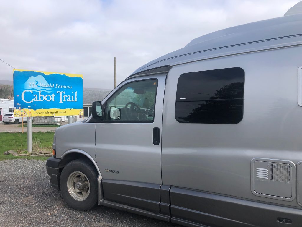
Savouring Cape Breton Island
When that itch for a scenic road trip hits hard, it’s a challenge to find a spot more delightful than Cape Breton Island, perched a short drive from mainland Nova Scotia. The island is renowned for the rugged coastline drive along the jaw-dropping Cabot Trail . . ....
Why not Alabama?
We rolled into the border crossing in Detroit this past January, towing our 5th wheel trailer, stopped and handed over our passports to the Agent. He glanced at the trailer, then us – “Heading to Florida are you” he asked as he scanned the passports. “No,...
Gas or Diesel: How to Decide
Why do I love diesel? I blame my father. In 1970 I was twelve years old, sitting home during March break. The phone rang and my dad asked me, “do you want to go to Florida?” Of course I did. “Well pack a bag and I’ll be home in 20 minutes to get you.” In 1970 my...

